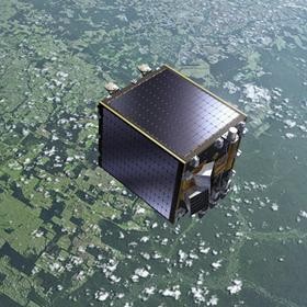
Proba-V satellite. The ’V’ in its name stands for Vegetation: Proba-V will fly a
reduced-mass version of the Vegetation instrument currently on board the
Spot satellites to provide a daily overview of global vegetation
growth. The Proba satellites are part of ESA’s In-orbit Technology
Demonstration Programme: missions dedicated to flying innovative
technologies.
A new project, led by scientists at UCL, is helping to build better simulations of weather and climate by mapping how much sunlight is being absorbed and reflected by the Earth. The amount of sunlight being absorbed or reflected by Earth is one of the driving forces for weather and climate. Satellites are providing this information with unprecedented accuracy. The ESA project, called GlobAlbedo, is using satellite data to map changes in Earth's reflectivity. The reflecting power of a surface is known as 'albedo'. Bright snow and ice have a high albedo, meaning they reflect solar radiation back into space, while green areas like forests and fields have a much lower albedo. The lower the albedo, the more energy from the Sun is absorbed.
TO READ THIS ARTICLE, CREATE YOUR ACCOUNT
And extend your reading, free of charge and with no commitment.